Find's Treasure Forums
Welcome to Find's Treasure Forums, Guests!
You are viewing this forums as a guest which limits you to read only status.
Only registered members may post stories, questions, classifieds, reply to other posts, contact other members using built in messaging and use many other features found on these forums.
Why not register and join us today? It's free! (We don't share your email addresses with anyone.) We keep email addresses of our users to protect them and others from bad people posting things they shouldn't.
Click here to register!
Need Support Help?
Cannot log in?, click here to have new password emailed to you

You are using an out of date browser. It may not display this or other websites correctly.
You should upgrade or use an alternative browser.
You should upgrade or use an alternative browser.
14 inches down, Missouri State Guard Camp
- Thread starter DWild
- Start date
Steve(Can)
Well-known member
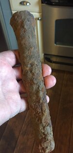
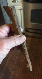
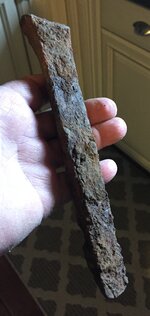
A plug, used with feathers, for splitting rock
Steve(Can)
Well-known member
Depends on the rock, DWild. The plugs and feathers were generally used to split quarried stone into blocks or slabs. The piles of rock you are talking about could have been rubble, chunks discarded in the process, in which case they'd have sharp edges and signs of working. If the rocks in the piles are smooth and rounded, maybe cracked in half or quarters, then they'd likely be a result of clearing ground for plowing, a regular chore each spring as an new crop of rocks appeared out of the ground and farmers used stone boats to haul them to the piles along the edges of the field. Besides plugs and feathers, most stone can be split like firewood, along the grain with a sledge. As well, in the early days when they were clearing and building roads, they'd pile brush on a protruding boulder and set a good fire to burn on top and around, then pour water over the heated rock to crack it apart.
The area I am from is on the northern most point of the Appalachian mountain range that extends from the southern states into Canada. That whole range is rich in upcroppings of different rocks and minerals. My great-grandfather on my mother's side was brought in to oversee the operation of a marble quarry in the area. As a lad, my grandfather worked as a hired hand at the quarry and married the fellow's daughter. They cut giant slabs of a pearly white marble with a characteristic fine grey grain running through it. It was a fairly small operation, but the marble was shipped far and wide, used as architectural stone, for example, the steps of the Canadian parliament in Ottawa, as well as tombstones and monuments. It was abandoned in the 40's, but I could take you in there, overgrown but looks pretty much like the day it was left... piles of rubble, drill marks running down the bare face of the marble wall, plugs and feathers protruding here and there, still wedged and in place where they were pounded into the rock.
Similar marble outcropping extend down into Arkansas and Tennessee. Arkansas stone, another marble type rock, has long been prized by woodcarvers as a sharpening stone. In the early days in my area they also mined corundum used as a sharpening stone, feldspar for gunpowder, iron and then post-war, uranium. Not far to the south, there is an area of an ancient inland sea bed, lots of limestone that they quarried for building blocks and talc and such.
Whereabouts are you, DWild, any sort of relevant history of the area, the earthworks and such?
Last edited:
I am in NW Missouri. This site was a well known recruitment camp for the Missouri State Guard in late 1861. There were at least 1500 and history says maybe up to 3,000 recruits. The owner said his father had no interest in history but told him about the earthworks he removed in order to farm. This was probably in the 1940'S. There are no photos that I can find. The family has none. The owner told me he had never really told anyone about the earthworks before. You can search my back posts to see some of the stuff that came out of this spot. We have probably found over 300 dropped round balls many with sprues. Also broken spurs, coins, minie balls etc. Most all of it concentrated in this area where he said the earthworks was. The main camp was across the creek and a good quarter mile away. The earthworks would have been between the MSG camp and the known Union Camp that was about 20 miles away. His dad said that there were piles of rock everywhere around and behind the earthworks.
The MSG recruits went straight to the battle of Lexington Missouri from this camp. The MSG is an oddity. They really did not have official uniforms or any standard equipment until they got further south into Arkansas and officially joined the Confederate Army. Most lead we find is from pistols and that is most likely what they had to bring with them. Very little big bore stuff and almost none of it shot or rammed. I am guessing they the men manning the earthworks defense spent most there time molding lead. They sure lost a lot of it.
One other interesting detail is that Mary Todd Lincoln's nephew was recruited at this camp. I will have to go back to the history records to find his first name but his last name was Todd.
Steve(Can)
Well-known member
Wow, how exciting DWild!
Not sure if this includes the type of earthworks or quarry the owner's father spoke of or goes back that far.... but maybe worth a look.... a map of abandoned mines in Missouri:

 www.americangeosciences.org
Not sure if this includes the type of earthworks or quarry the owner's father spoke of or goes back that far.... but maybe worth a look.... a map of abandoned mines in Missouri:
Geoscience Intersections
www.americangeosciences.org
Steve(Can)
Well-known member
This puts a couple limestone quarries in the immediate neighbourhood:
also more info about plugs and feathers

 en.wikipedia.org
Not sure about the connection to the civil war earthworks, other than maybe they brought wagon loads of nearby rubble to fortify the structure?
Missouri - Quarry Links and Photographs
quarriesandbeyond.org
also more info about plugs and feathers
Plug and feather - Wikipedia
Not sure about the connection to the civil war earthworks, other than maybe they brought wagon loads of nearby rubble to fortify the structure?
Steve(Can)
Well-known member
Geological Map of Missouri Showing the Location of the Principal Stone Quarries (1904), based on Broadhead Map of 1873, and Keyes Map of 1896. The following types of features are shown on the map: Limestone, Sandstone, Lime-kiln, Silica and Tripoli, and Granite and Rhyolite. Limestone quarries indicated with a red rectangle.
