99thpercentile
New member
I didn't see a geophysics sub-forum here, so I picked the Resource & Classroom Forums. I am geophysicist who works all over the world using a whole range of methods and tools. The instruments that we typically use for geophysical metal detecting are referred to as Digital Geophysical Mapping (DGM) instruments in that they all record all of the instrument data as well as metadata. So for example a Geonics EM61-MK2 metal detector is a push cart system that can detect a 55 gallon drum to a depth of 10+ ft (~3 m). The wheels act as a distance trigger and we typically use a RTK GNSS receiver with the unit so that we can locate our targets to around 1 cm. The date file contain the date, time, latitude, longitude, elevation, and all of the sensor output.
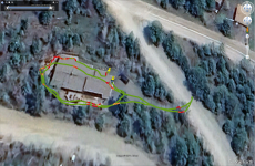
Here is a picture of me walking around my yard with a CEIA CMD metal detector with the GSMD-GPS unit attached. This is a military use metal detector where a GPS unit can be integrated. Unfortunately, this isn't really a DGM instrument as I can only download a Google Earth KMZ file that contains position and some data, but not good quality data. Also the GPS unit is probably only accurate to 1 m. The system also only records 1 sample per second, whereas most of my geophysical instruments can record a minimum of 5 samples per second, with most being able to do 15-20 samples per second.
Let me know if you have any questions about this system or geophysical metal detectors in general.