Find's Treasure Forums
Welcome to Find's Treasure Forums, Guests!
You are viewing this forums as a guest which limits you to read only status.
Only registered members may post stories, questions, classifieds, reply to other posts, contact other members using built in messaging and use many other features found on these forums.
Why not register and join us today? It's free! (We don't share your email addresses with anyone.) We keep email addresses of our users to protect them and others from bad people posting things they shouldn't.
Click here to register!
Need Support Help?
Cannot log in?, click here to have new password emailed to you
You are using an out of date browser. It may not display this or other websites correctly.
You should upgrade or use an alternative browser.
You should upgrade or use an alternative browser.
Drone photography.
- Thread starter Nauti
- Start date

Nauti
Well-known member

This is St Lawrence church in a place called Bidford on Avon in Warwickshire,England.It dates from the 1200's with one part being from the 1100's.To the right of the church down by the river,was the original crossing of Ryknield street (now ickneild street),the original ford used by Roman soldiers and Roman citizens to cross the river.
Nauti
Well-known member


This is St Leonards church in Beoley,warwickshire,England.Dating back to the Norman period in the 1100's but built on the site of an earlier saxon church.The fields surrounding the church were detected by a friend of mine and myself with Saxon,Roman and Medieval artefacts being found as well as many Georgian and Victorian finds.
The other photo shows what is left of a hilltop fortification directly opposite the church,probably an early wooden structure which later became a fortified manor house.The trees surounding the site hide 20 foot deep ditches which would have made it difficult to attack.The gap in the trees seen at the bottom right was probably the entrance to the site.As of now,no archeological dig has taken place at the site.
Odanscoils
Well-known member
Man that's cool.
Odanscoils
Well-known member
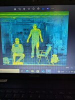
Here's a thermal image I took of a friend and myself. Oh and his pooch Molly.
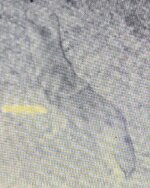
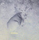
Big buck and coyote stalking my neighbors sheep
Big buck and coyote stalking my neighbors sheep
Attachments

Nauti
Well-known member


This is Bordesley Abbey....most of what is left is still under the field and has not been excivated.It was built in the 1200's and was out of use by the late 1500's.The grid like structure to the right of the main ruins was the Abbey infirmary.The stone coffin was the final resting place of a man called Guy De Beauchamp,Earl of Warwick,who died in the early 1300's,the other two coffins in the floor of the Abbey were likely to be the resting places of two highr ranking monks who served at the Abbey.
The other photos show the site of a chapel which served the Abbey......the flat area to the left of the redwood tree,to the right of the tree is an ancient graveyard that dates back to the 1500's........one headstone can easily be read with the date 1635.Most of the headstones were made from the rubble of the abbey when it was demolished in the 1500's and were burials of poorer people who couldn't afford properly made grave markers.
Last edited:
Odanscoils
Well-known member
I'll pm you.How did you do that,what gear did you use.
Odanscoils
Well-known member
So cool to have those sites around you.View attachment 79745View attachment 79743View attachment 79744View attachment 79746View attachment 79747View attachment 79748View attachment 79749
This is Bordesley Abbey....most of what is left is still under the field and has not been excivated.It was built in the 1200's and was out of use by the late 1500's.The grid like structure to the right of the main ruins was the Abbey infirmary.The stone coffin was the final resting place of a man called Guy De Beauchamp,Earl of Warwick,who died in the early 1300's,the other two coffins in the floor of the Abbey were likely to be the resting places of two highr ranking monks who served at the Abbey.
The other photos show the site of a chapel which served the Abbey......the flat area to the left of the redwood tree,to the right of the tree is an ancient graveyard that dates back to the 1500's........one headstone can easily be read with the date 1635.Most of the headstones were made from the rubble of the abbey when it was demolished in the 1500's and were burials of poorer people who couldn't afford properly made grave markers.
Keep on a posting.
Odanscoils
Well-known member
Drone images.How did you do that,what gear did you use.
Welp to get the images to load here.
I took a phone photo of the image on my laptop which I download my drones SD card to.
Then I still had to crop out the drone flight data in the image to make it small enough to load here.
Still can't figure out those images sizing apps you mentioned.
The coyote and deer were with onboard night vision camera at 300' using the onboard IR illuminator.
I can't see it at all.
Though that coyote sure did.
Must have tried 50 shots to get that one.
Everytime the IR light hit him he moved.
Finally got behind him and got the shot.
Didn't know they could see that light.
Completely invisible to humans.
Last edited:
Nauti
Well-known member

This is Watermouth cove.The tower is thought to be some sort of lookout tower associated with the castle in the background and it was used as a lookout tower in WW2.The castle is not old and was built in the 19th C but it may have been built on the site of a temporary Roman marching camp.....Roman pottery and coins have been found in the bay.
Odanscoils
Well-known member
This is the latest version they use.Brilliant technology,makes you wonder how many government drones are flying out of earshot keeping an eye on us.
Can read a licence plate at close to a mile.
Nauti
Well-known member

Combe Martin in north Devon,once held the world record for the longest street party.The spit of rocks going across the bay was put there as a barrier in medievil times to protect ships that were moored.....it used to be a lot higher but has been battered over the years by storms reducing it to what you see now.
Odanscoils
Well-known member
Like I said before.
You have the coolest history over there.
Ever go detecting there ?
Could dig up some awesome history.
You have the coolest history over there.
Ever go detecting there ?
Could dig up some awesome history.
Nauti
Well-known member
Been a couple of times,i used to live there........i believe a few gold coins have come off the bay,unfortunately i didn't find them.
There is a bit of Roman history in the village which has come up during official digs as the area is known for its silver.Also there are medievil lime kilns in the area.
There is a bit of Roman history in the village which has come up during official digs as the area is known for its silver.Also there are medievil lime kilns in the area.
Odanscoils
Well-known member
Cool. I'd be going in at low tide detecting.Been a couple of times,i used to live there........i believe a few gold coins have come off the bay,unfortunately i didn't find them.
There is a bit of Roman history in the village which has come up during official digs as the area is known for its silver.Also there are medievil lime kilns in the area.
Around the old docks and loading un loading areas.
Where any merchants money exchanged hands.
Don't forget on many detectors.
Gold at depth usually comes in around the top of iron signals.
And commonly a 1-10 at low end of conductive.
Odanscoils
Well-known member
Hey Nauti,
Need some more beautiful pics ...
Matric 4T.
Need some more beautiful pics ...
How did you do that,what gear did you use.
Matric 4T.