F_27stryker1
Active member
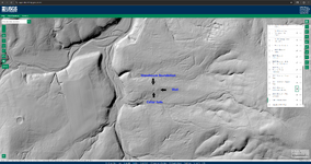
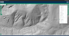
I know most already know about lidar and how it sees through trees to the ground, but I just wanted to point out an example for anyone on the fence or not using the technology yet. If you'll look at the USGS map with 3DEP hill shade enabled, it will clearly show what's below the tree canopies and with surprising detail. After confirming the site, and through some digging, it dates to about the 1850's, which isn't the oldest in the area, but still a good spot to hunt.
If you want to check the site out for yourself, here is the link https://apps.nationalmap.gov/viewer/ Top right of the screen are the layers you need to go through, enable 3DEP Hillshade
If you want to check the site out for yourself, here is the link https://apps.nationalmap.gov/viewer/ Top right of the screen are the layers you need to go through, enable 3DEP Hillshade